Nigeria's Flood Crisis (2022–2025): Human Impact, Displacement, and Vulnerability Patterns
Flooding has become one of Nigeria's most severe and recurring climate risks. Evidence from 2022–2025 shows widespread human impact across multiple states and LGAs, with large-scale displacement, infrastructure damage, and livelihood disruption.
Executive Summary
Flooding has become one of Nigeria's most severe and recurring climate risks. Evidence from 2022–2025 shows widespread human impact across multiple states and LGAs, with large-scale displacement, infrastructure damage, and livelihood disruption. The burden is heaviest in riverine and low-lying areas, and falls disproportionately on children, women, the elderly, and persons with disabilities, highlighting flooding as both a climate and social vulnerability crisis.
Human Impact of the 2022 Floods: Geographic and Demographic Distribution
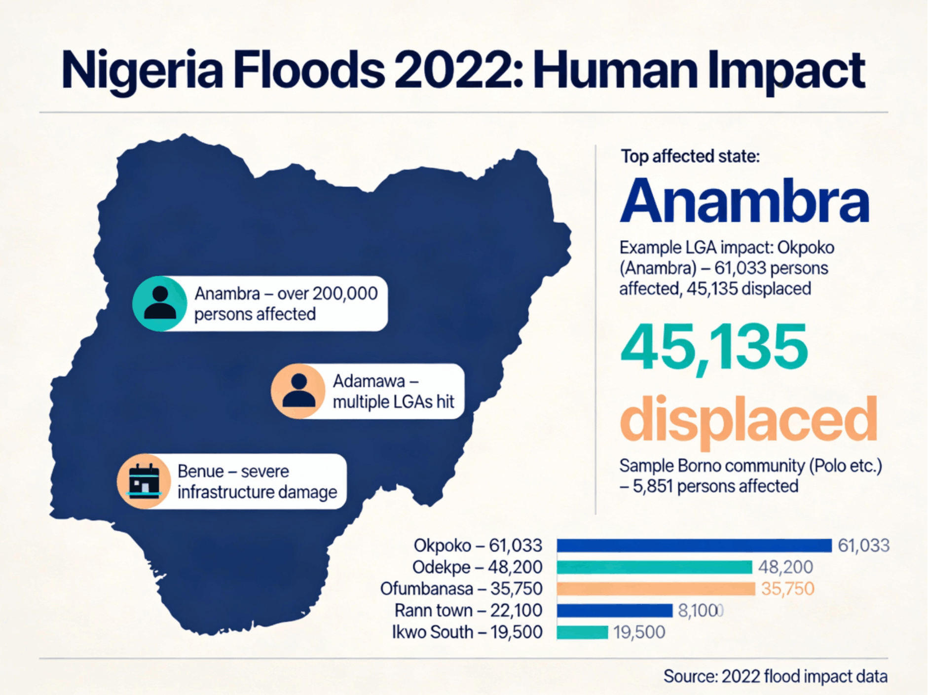
The 2022 floods caused widespread human displacement and disruption across Nigeria, with the most severe impacts concentrated in riverine and low-lying states. The disaster particularly affected densely populated urban and peri-urban communities, where prolonged rainfall and river overflow overwhelmed housing, transport networks, and basic services.
Anambra State emerged as the epicentre of the crisis, with over 200,000 people affected. Flooding along the River Niger displaced entire neighbourhoods and disrupted livelihoods, schooling, and access to healthcare.
At the community level, the scale of impact was most pronounced in Okpoko LGA (Anambra), which recorded:
- 61,033 persons affected
- 45,135 persons displaced
This made Okpoko one of the single largest displacement hotspots in the country during the 2022 floods.
In the North-East, Adamawa State experienced flooding across multiple Local Government Areas, with communities along the Benue River basin facing extensive residential and agricultural losses. Benue State in the North-Central zone suffered severe infrastructure damage, including roads, bridges, schools, and health facilities, complicating emergency response and recovery efforts.
Community-level data further illustrates the localized concentration of flood impacts:
- Okpoko – 61,033 affected
- Odekpe – 48,200 affected
- Ofumbanasa – 35,750 affected
- Rann Town – 22,100 affected
- Ikwo South – 19,500 affected
- Selected Borno communities (e.g., Polo) – 5,851 affected
Together, these patterns demonstrate how extreme flooding in 2022 translated into large-scale internal displacement and infrastructure loss, reinforcing the growing link between climate hazards, urban vulnerability, and humanitarian risk in Nigeria.
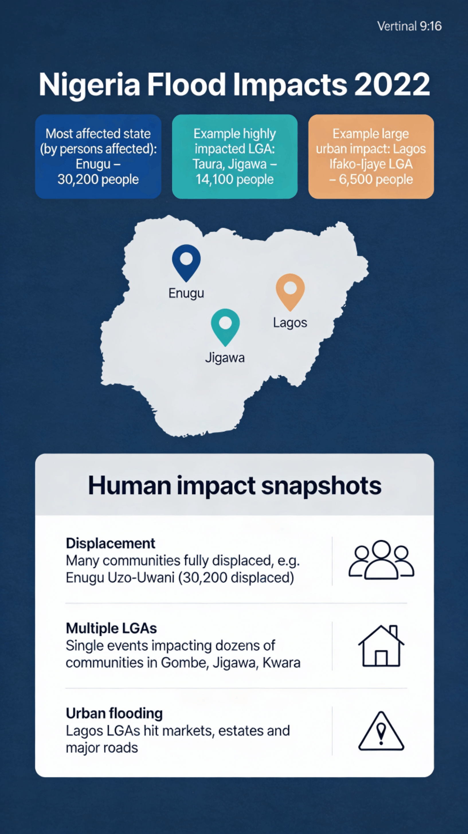
Human Impact Patterns Across States and Urban Centres
The 2022 floods affected communities across all geopolitical zones, with both rural riverine areas and major urban centres experiencing significant human and economic disruption. The distribution of impacts highlights how climate-induced flooding now cuts across state boundaries and settlement types.
Enugu State recorded one of the highest numbers of affected persons, with 30,200 people impacted, including large-scale displacement in communities such as Uzo-Uwani, where entire settlements were forced to evacuate.
In the North-West, Taura LGA in Jigawa State exemplifies the scale of localized rural impact, with 14,100 people affected by a single flood event, reflecting the vulnerability of agrarian communities situated along floodplains and seasonal river systems.
Urban exposure was also pronounced. In Lagos State, flooding in Ifako-Ijaye LGA affected approximately 6,500 residents, disrupting markets, residential estates, and key transport corridors, and underscoring the growing risk of pluvial and drainage-related flooding in rapidly urbanizing cities.
At a national level, three dominant human-impact patterns emerged:
- Large-scale displacement: Entire communities were forced from their homes, as seen in Enugu Uzo-Uwani, with tens of thousands of residents displaced.
- Multi-LGA events: Single flood episodes simultaneously affected dozens of communities across states such as Gombe, Jigawa, and Kwara, stretching emergency response capacity.
- Urban flooding: Major metropolitan LGAs, particularly in Lagos, experienced severe surface flooding that disrupted economic activity and critical infrastructure.
These patterns demonstrate that Nigeria's flood risk is no longer confined to isolated rural areas but now represents a systemic national challenge affecting both densely populated cities and climate-sensitive rural regions.
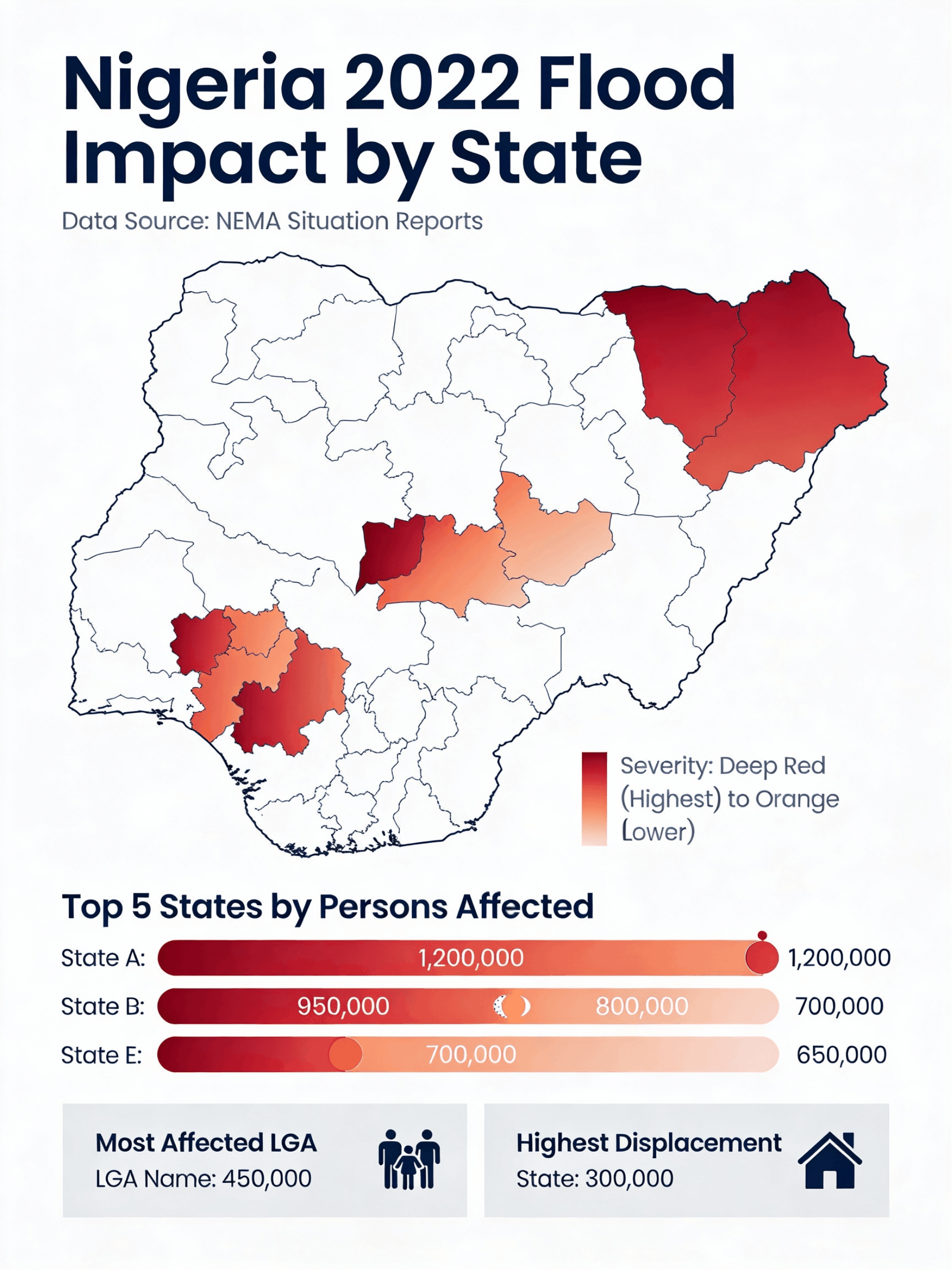
State-Level Severity and Concentration of Impact
State-level assessment of the 2022 floods shows a highly uneven distribution of impact across the country, with a cluster of states recording extreme levels of exposure and displacement. Severity mapping indicates that the most affected states were concentrated along major river basins and low-lying inland corridors, where prolonged rainfall and river overflow produced sustained inundation.
Analysis of NEMA situation reports identifies a group of states in the highest severity category (deep red), each recording hundreds of thousands of affected persons. The top tier of impact included states with:
- Over 1.2 million people affected in the single worst-hit state
- A second tier of states with approximately 950,000 to 800,000 people affected
- Additional high-impact states with 650,000–700,000 affected residents
At the sub-state level, the scale of disruption was even more pronounced:
- The most affected Local Government Area recorded over 450,000 people impacted, reflecting near-total community inundation.
- The state with the highest displacement burden registered over 300,000 internally displaced persons, placing exceptional pressure on emergency shelter, health services, and humanitarian logistics.
This concentration of impact underscores the systemic exposure of Nigeria's flood-prone states, where population density, river hydrology, land-use patterns, and limited drainage infrastructure converge to produce large-scale humanitarian outcomes during extreme rainfall events.
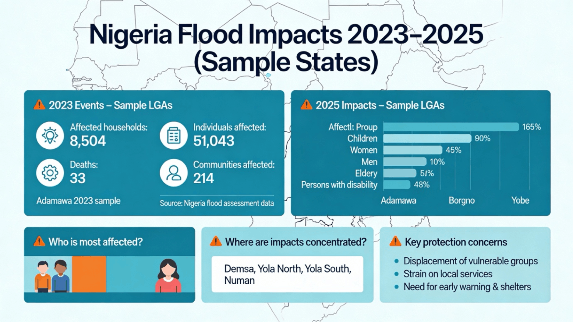
Escalating Human Vulnerability: 2023–2025 Flood Impacts (Sample States)
Post-2022 assessments indicate that flood impacts in Nigeria have remained persistent and are increasingly concentrated among vulnerable population groups, particularly in the North-East.
In Adamawa State (2023 sample LGAs):
- 8,504 households were affected
- 51,043 individuals impacted
- 214 communities recorded flood damage
- 33 fatalities were reported
These figures point to repeated exposure of the same flood-prone settlements, with cumulative humanitarian and livelihood losses over successive years.
By 2025, impact profiling across sample LGAs in Adamawa, Borno, and Yobe shows disproportionate effects on specific social groups:
- Children: up to 90% exposure in some LGAs
- Women: approximately 45% affected
- Elderly: over 50% impacted
- Persons with disabilities: close to 48% affected
- Men: lower relative exposure (around 10%), reflecting mobility and evacuation differences
Spatial concentration of impacts is highest in river-adjacent and low-lying LGAs, notably:
- Demsa
- Yola North
- Yola South
- Numan
Key protection and resilience concerns emerging from these patterns include:
- Large-scale displacement of vulnerable groups
- Severe pressure on local health, shelter, and social services
- Critical gaps in early warning systems, evacuation planning, and flood-resilient shelter infrastructure
Together, the 2023–2025 data illustrate that flood risk in Nigeria is becoming both chronic and socially unequal, with children, women, the elderly, and persons with disabilities bearing a disproportionate share of climate-related harm.
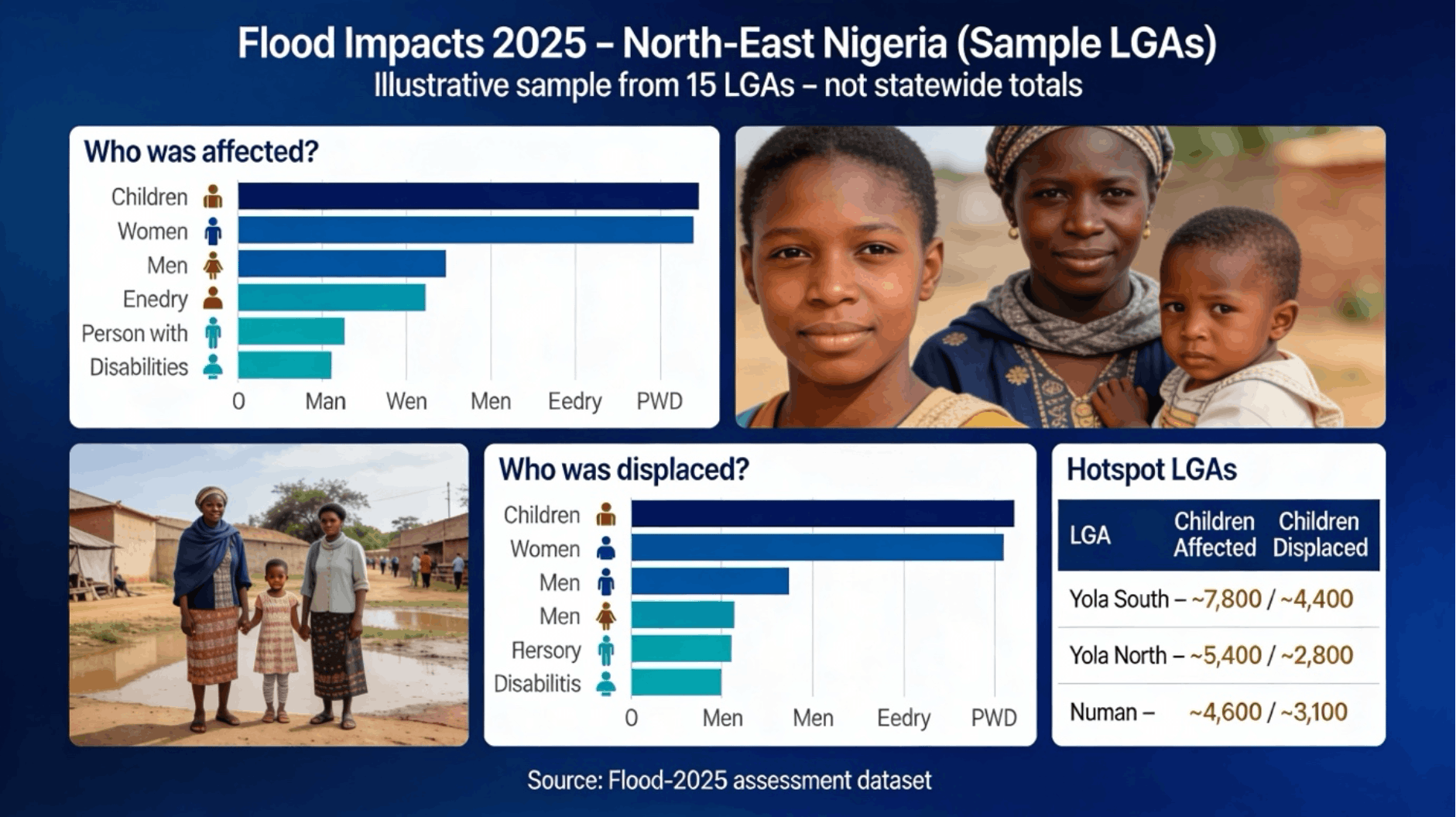
Differential Impact and Displacement in North-East Nigeria (2025 Sample LGAs)
Assessment of flood impacts across selected LGAs in the North-East in 2025 shows a clear concentration of harm among vulnerable population groups, with children and women accounting for the largest share of those affected and displaced.
Overall exposure patterns indicate that:
- Children represent the most affected group, reflecting high vulnerability in household-level flooding and displacement.
- Women also account for a significant proportion of those impacted, particularly in caregiving and household-dependent livelihoods.
- Men show lower relative displacement levels, partly due to mobility and migration for income.
- Elderly persons and persons with disabilities (PWDs), while smaller in absolute numbers, face heightened protection risks due to limited mobility and access to services.
Displacement trends mirror this pattern:
- Children and women form the majority of internally displaced persons (IDPs) in the sampled LGAs.
- Elderly and persons with disabilities experience disproportionate hardship in evacuation, shelter access, and continuity of care.
Hotspot LGAs with the highest concentration of affected and displaced children include:
- Yola South: ~7,800 children affected; ~4,400 displaced
- Yola North: ~5,400 children affected; ~2,800 displaced
- Numan: ~4,600 children affected; ~3,100 displaced
These figures highlight the strong spatial overlap between flood exposure and population vulnerability in the Benue River corridor of Adamawa State. The data underscores that flood risk in the North-East is not only a physical hazard but a child- and gender-intensive humanitarian challenge, with long-term implications for education, nutrition, health, and social protection systems.
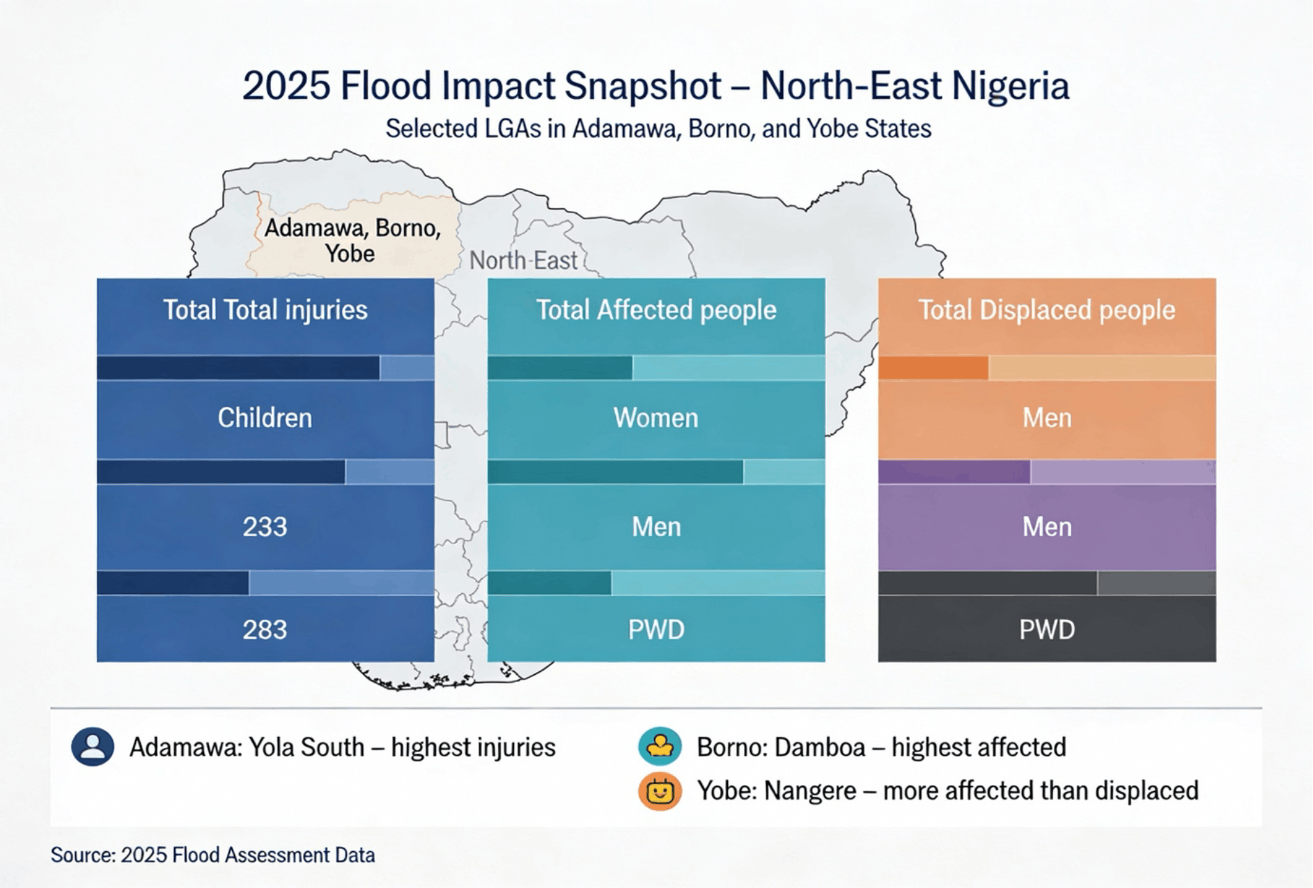
Injury, Exposure, and Displacement Patterns in the North-East (2025 Sample LGAs)
A 2025 flood impact snapshot for selected LGAs in Adamawa, Borno, and Yobe States shows differentiated human outcomes across injury, exposure, and displacement, with clear demographic and geographic concentration.
In terms of injuries, children and other vulnerable groups were disproportionately affected, with reported injury figures in the hundreds across sampled LGAs, reflecting both physical exposure during flooding and limited access to early evacuation and medical response.
Patterns of total affected population indicate:
- Women and men forming the largest share of those exposed to flood impacts.
- Persons with disabilities (PWDs) representing a smaller but highly vulnerable group, facing elevated risks due to mobility constraints and access barriers during evacuation and recovery.
For displacement, the data shows:
- Men and women accounting for the majority of those forced from their homes.
- PWDs experiencing significant displacement relative to their population size, highlighting protection and shelter accessibility gaps.
Geographic hotspots within the sample states include:
- Yola South (Adamawa): Highest number of flood-related injuries.
- Damboa (Borno): Largest number of people affected overall.
- Nangere (Yobe): Higher numbers of affected persons relative to those displaced, suggesting partial in-place impact with constrained evacuation.
These patterns reinforce that flood risk in the North-East is not uniform: impacts vary by age, gender, disability status, and location, and require targeted preparedness, evacuation planning, and inclusive recovery systems tailored to the most exposed LGAs and population groups.
Conclusion
The 2022–2025 flood patterns confirm that flooding in Nigeria is no longer episodic but structural. Without stronger early warning systems, resilient infrastructure, and targeted protection for vulnerable groups, future flood cycles will continue to drive displacement and humanitarian strain. Building climate resilience is now essential to safeguarding lives, development gains, and long-term stability.
About This Research
This policy brief is part of YCTF's ongoing research into Nigeria's climate vulnerability and adaptation pathways. The analysis is based on NEMA situation reports, state-level assessments, and field data from affected communities. For the full technical report and methodology, please contact our research team.